Ascent of Mount Aspiring (3033 m), New ZealandJanuary 5, 2007 (Klik her for at læse historien på dansk |
|
|
Mountain climbing in New Zealand is characterized by three things: long approaches, loose rocks and bad/changeable/unpredictable weather. So I guess it seems strange that Elvira and I chose to climb Mt Aspiring as our most recent endeavor.
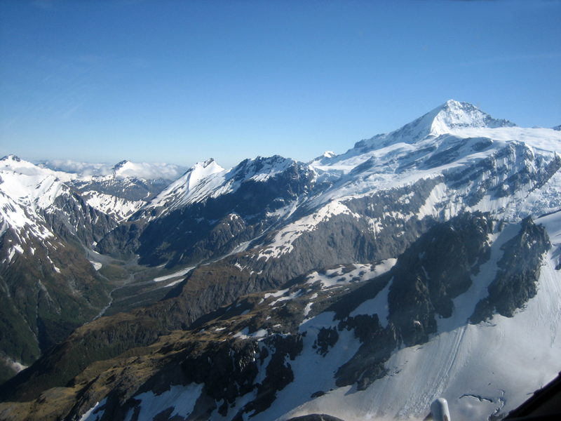
Mount Aspiring and the French Ridge seen from the helicopter "approach". Move the mouse cursor over the picture to see summits and other hallmarks. | |
One of the big advantages of climbing in New Zealand is that there are a million other things to do whilst waiting for a weather window. We arrive 28. Dec 2006 and quickly discover the weather is surprisingly cold and wet for this time of year. In contrast to the warm winter weather Denmark had in December, New Zealand had the coldest summer in 40 years. We decide to ‘warm-up’ by walking the "The Northern Circuit" – which is a 55 km round-trip over the most beautiful volcanoes on the North Island. The trip is conservatively estimated to taking 3-4 days, but we spend 2, which confirms that our training has not been a waste of time. This reinforces the self-esteem needed for our marathon summit and approach/descent. The trip also gives us an opportunity to shake some of our 12 hour jetlag. We then start driving toward the South Island, here we continue down the east coast in pretty bad weather whilst continually checking the weather forecast on the net.
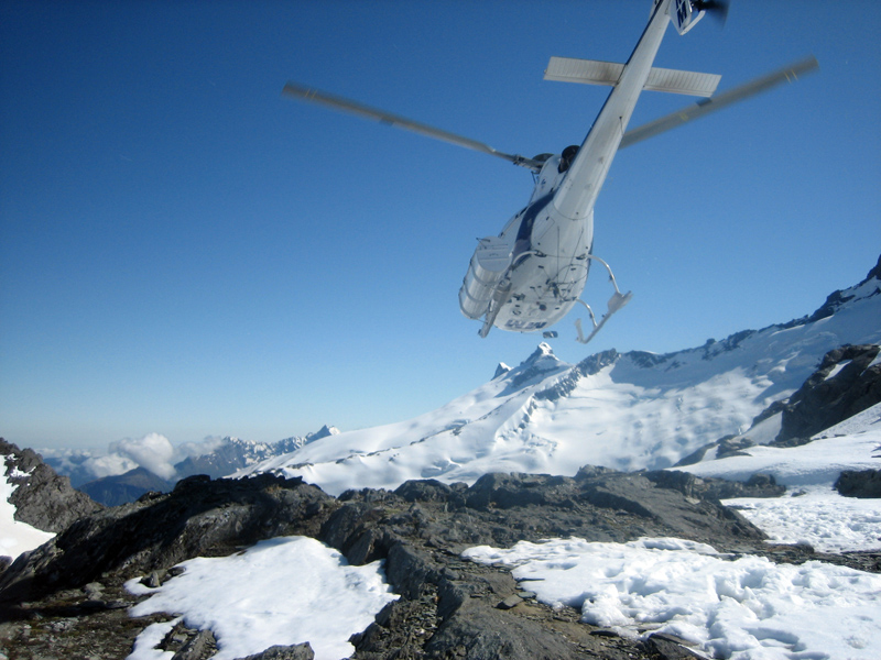
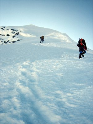
The helicopter leaves us at the Bevan Col. The Colin Todd hut is located on the rock ridge sligthly to the left on the picture. |
|
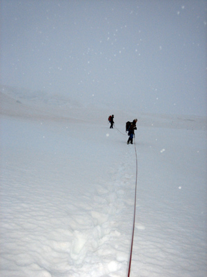
The weather is perfect – high sun and no wind – we quickly tie-in and walk over the glacier toward the hut which we have spotted on a rock ridge at the other side of the basin. There are only a few crevasses and the snow is still relatively solid, so it feels easy and safe. On our way we meet a few other rope teams on their way ’home’ after successful summits. We are told that route conditions are perfect, so our optimism grows!
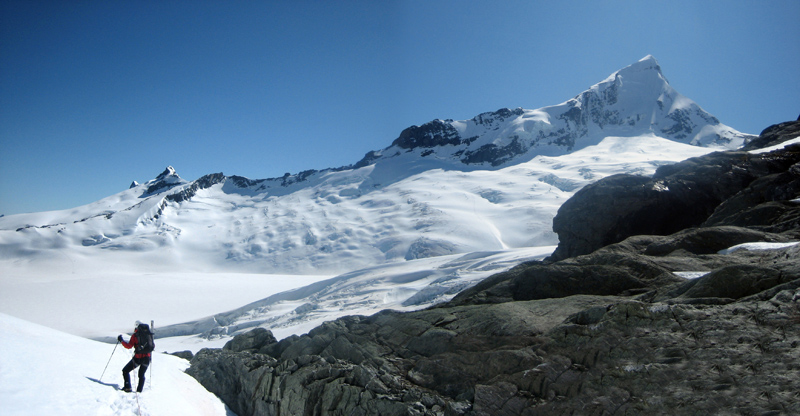
Elvira enjoying the view of Mt. Aspiring from Bevan Col. Move the mouse cursor over the picture to see the route and hallmarks. |
|
On arrival at the hut we meet two kiwis who have just spent two days walking up from the car park - respect! A little later three groups that had climbed the northwest route that day arrive. They give us some valuable beta about the route which once again confirms that the ramp and the upper part of the ridge is in perfect condition. However, whilst chatting, a sign on the wall of the hut from the Department of Conservation warning not to climb the ramp as it has been the scene of several fatal accidents, catches our attention. But due to the snow on the lower part of the rock ridge we exclude this possibility. It’s the ramp or nothing .....
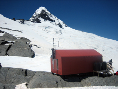
NW ridge seen from the Colin Todd hut. |
The forecast that evening informs us that the weather window was due to close the following afternoon and be replaced by 90 km/t winds and rain, which is why we all agreed on an early alpine start the following morning at 2:00 AM. The plan was to get down the ramp whilst the snow was still solid and before the weather changed. The clock ticks ....
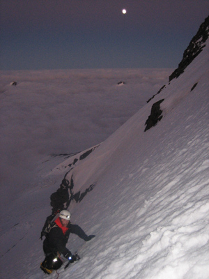
Elvira ascending "The Ramp" on Mt. Aspiring's NW ridge. |
The start of the ramp is steepest (55°) after which it flattens out to 40-45°. We start climbing our first 3-4 pitches by using belays (without protection in between) consisting of a snow stake and an ice axe. This was followed by climbing parallel with protection between us (T-blocks in snow stakes ca. 6 pitches) until we ended up climbing parallel without protection. The snow is so solid that the snow stakes have to be hammered in using our ice axes, and to my utmost surprise I actually think they would have been able to stop a fall!
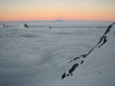
Elvira and the two kiwis on the snow ramp above the clouds with a view to Mt. Aspiring's shadow in the horizon, the full moon and the most beautiful sunrise. |
We climb in the moonlight above the clouds and can slowly see the sun rise whilst the shadow of Mt Aspiring appears on the horizon – its the most beautiful sight I have ever seen in the mountains! We get to the top of the ramp after 3.5 hours of climbing and start out on the northwest ridge. The steepness drops whilst the exposure increases.
Elvira approaching the top of the ramp, where it joins the NW ridge. |
The ridge is comfortably wide so we can walk in zigzag to reduce the inclination of the slope and we continue quickly upwards – and suddenly 1.5 hours after leaving the ramp we reach the summit. We are met with strong winds and the most fantastic panoramic views.
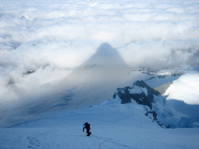
Elvira ascending the NW ridge in the beautiful shadow of Mt. Aspiring. The Ramp joins the NW ridge at the top of the rocks seen below Elvira. |
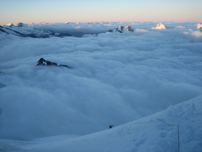
We are above the clouds and only the highest peaks, such as Mt. Cook, peep up above them. We take the compulsory summit pictures and begin our descent toward the ramp, which is luckily still above the clouds when we reach it.
The two kiwis in zigzag on the last part of the NW ridge. |
Despite climbing the ramp with protection on our ascent we have climbed relatively quickly, and combined with our early start we now reach the ramp whilst it is still in good condition. Cool – our climbing strategy worked! We start climbing parallel until the ramp becomes too steep for Elvira’s safety. After which I secure her a few pitches until we arrive at the rock outcrop just above the last, steepest pitch with the thinnest cover of snow.
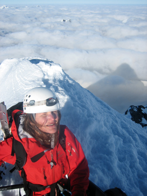
Elvira on the summit of Mt. Aspiring with its beautiful Toblerone shadow in the background. Click on the picture to view a 360° panorama movie from the summit (requires installation of Quicktime). |
We find an anchor and after conferring with the two kiwis we decide to use both our ropes as this would get us all the way over the bergschrund. After the abseil its “plain sailing” all the way back to the hut which we reach after 10 hours of climbing. A satisfying time for 1200 vertical meters and 4000 horizontal meters, as the guide books state that a normal time is 11-13 hours and that some of the slowest have spent 16 hours!
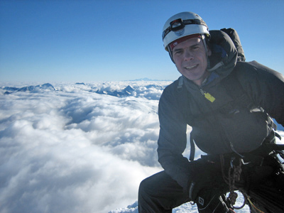
Hans on the summit of Mt. Aspiring. Mt. Cook is just visible in the horizon. |
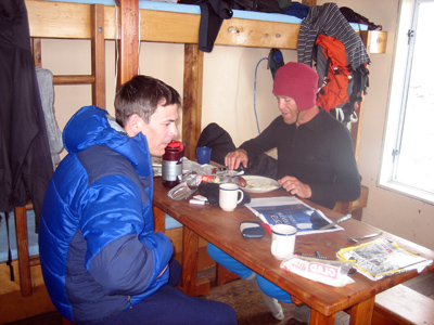
Back at the hut we ’party’ when we find that the 6 climbers that left that morning also left some edible goodies behind for us. The two kiwis eat so much I can’t believe my eyes! But on our descent the following day I realize their strategy – they were reloading for the hard climb down. Something Elvira and I underestimated. As they say: “It ain’t over ‘til the fat lady sings”!
Glenn and Hans "partying" in the Colin Todd hut. |
That afternoon it begins raining at the hut – the weather is beginning to change as predicted. To enable us to get over the glacier whilst it’s cold we use a semi-alpine (5:00 AM) start the next morning. This proves useless as the rain had gotten more intense overnight and we ended up walking in deep, soft snow! We agree that it is safest with all four of us roped into one rope so putative falls into crevasses could be secured with a little more ease. This gives Elvira and myself an advantage as the two kiwis know the glacier and we take the same route they climbed up two days earlier – furthermore the thick cloud cover makes orientation by using the surrounding mountains difficult.
The two kiwis leading the Bonar glacier in white-out. |
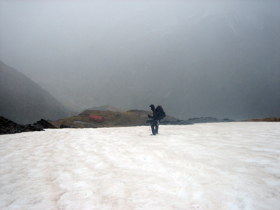
Before we flew up I was in doubt as to whether I should choose my softshell or hardshell jacket, my personal favorite when climbing is the softshell which only protects against rain for approximately 10 minutes.... I chose my softshell, which proved to be a bad choice as I got totally soaked. It wasn’t cold but the wind grew stronger as we approached the pass toward “The French Ridge”. So by the time we reach the pass I am quite cold whilst I can see the others are much more comfortable behind their Gore-Tex jackets. Bad choice! Luckily, the kiwis know a short-cut via “Breakaway” pass at 2000 meter instead of “Quarterdeck” pass at 2300 meter which is described in the guide books. This saves us an hours glacier walking. The short-cut is only possible at this time of year for us because of the cold summer, which means a wicked bergschrund on the opposite side of the Breakaway pass is still passable. We can see the snow bridge is on its last verse as we descend it backwards, with a view into the deep (but beautiful) crevasse on both sides on the melting snow bridge. We get over in one piece and arrive at the French Ridge hut 6 hours later. It is normal practice to sleep here one night and continue the following day but we are wet and just want to get to dry clothes so we decide to continue. The route changes character completely: First we climb over rocks and moss in open terrain and then we begin climbing steeply downward on muddy rock and tree roots through a rain forest. It seems crazy coming from snow and ice to rain forest in just a matter of hours.
Hans on the last patch of snow before The French Ridge hut visible below on the plateau. Then it was down into the rainforest! |
|
We didn’t have rain covers for our backpacks with us and the latter thus function as a sponge so everything inside gets soaked. They now weigh twice as much and the route gets steeper and steeper so we at times climb backwards down slippery rocks and tree roots. We have no food left and can feel our low blood sugar - its tough and slow going. We finally reach the bottom of the French Ridge and have to choose between a river crossing or spending an extra hour walking up the valley to a bridge. We are soaked so the river crossing would have no impact on this, but still we choose the bridge as this seems safer than crossing through the rapids. After this we continue winding up and down toward the valley. It’s clear that this route is designed for appreciating the view and not for a fast retreat. There are big waterfalls covering both faces of the valley which makes us think of “The Lord of the Rings”, but we are actually too tired to fully appreciate the views .... 13 hours after leaving the Colin Todd hut we arrive at the parking area. Here we are pleasantly surprised to see our two kiwi friends waiting and the delight of our climb to the top of such a beautiful mountain settles within us. |
|